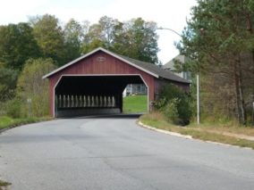
Covered Bridge
The SOUTH MONCK COVERED BRIDGE TRAIL travels on roadways, pipelines, open fields and through forested areas. Varying surfaces from pavement to dirt to difficult terrain.
Link to trail map: https://www.bracebridge.ca/en/be-active/resources/Documents/Bracebridge-South-Monck-Trail.pdf
We would also direct you to read our DISCLAIMER and our TRAIL USERS CODE.
Region(s): Muskoka DistrictNearby towns and cities: Bracebridge
Trail feature tags: Covered Bridge | Wheel chair accessible
SOUTH MONCK COVERED BRIDGE TRAIL characteristics
Length: 8 kmDifficulty: Moderate (Trail classifications)
Trail surface: Natural and Paved
Trail use: Hiking and Mountain biking
Partially wheelchair accessible
Accessibility Notes: partly wheelchair accessible
Fees: None
Flora & Fauna:
Not reported yet
Amenities: None
Attractions: Covered Bridge
Contact:
Town of Bracebridge
Find it: Take West Mall Rd, north off of Muskoka Rd 18 west and then turn right on Balls Dr. Then a quick left on Tamarack Trail Rd and park at Monsignor Michael O'Leary School.

GPS Coordinates (main trailhead):
Latitude: 45.0492000
Longitude: -79.3318000